Cumberland to Powhatan County

On Wednesday, after a good night's rest at Oakland Farm, I set out walking for Cartersville. It was a beautiful quiet morning after a rainy night. The six or so miles along Rt. 679 and Rt. 45 passed quickly as I ambled across the Willis River, by woods, front yards, and yes, Buckingham slate signs.  

It turns out they like Buckingham slate in Cumberland too.

Composting toilet?


Willis River, Rt. 679

I had been told to stop at Spanky's general store once I got into Cartersville. The official store name is Blanton and Pleasants, but Mr. Pleasants who has worked or owned the store for over 50 years goes by Spanky. Such nice people in such a neat old store. I knew this place was the real deal when a gentleman came in and asked Spanky for a haircut...general indeed.   
  
"Spanky"(in blue) has run his general store for 53 years.

While I took a load off and chatted with Spanky and his wife, June, I learned that the young woman at the register was their grandson's wife and one of the little girls playing in the aisles was their greatgrandaughter. What a fun place to grow up. June told me about some of the memorable floods that have turned the James River there into a torrent. Hurricane Agnes was the one that tore out the one lane bridge that connected the center of Cartersville to the south side of the river. I learned later that folks from the store set up a ferry service in the aftermath so that those living in the village could still come over the James to get provisions.  
The store has everything...


...even haircuts.

   
Spanky's great-granddaughter and her friends get to play together at the store.

Betty McCracken and Pam from the Monacan Soil and Water Conservation District in Goochland rolled up to Spanky's store around noon, with a canoe in the back of a pickup truck. Betty has gone out of her way to help me on my way through Powhatan and Goochland - the two counties she serves. In addition to arranging for several farms for me to visit as I pass through, she offered for us to canoe a stretch down the James River together. Pam dropped us off at the boat ramp and off we headed down river for a few miles. Betty told me about some of the work they do at the District, helping farmers design and pay for various conservation practices, such as putting up fences and alternative water supplies to keep cattle out of streams, rotational grazing methods, etc. 

Getting on the James with the wonderful Betty McCracken, for a short paddle from Cartersville to the Belmead property.
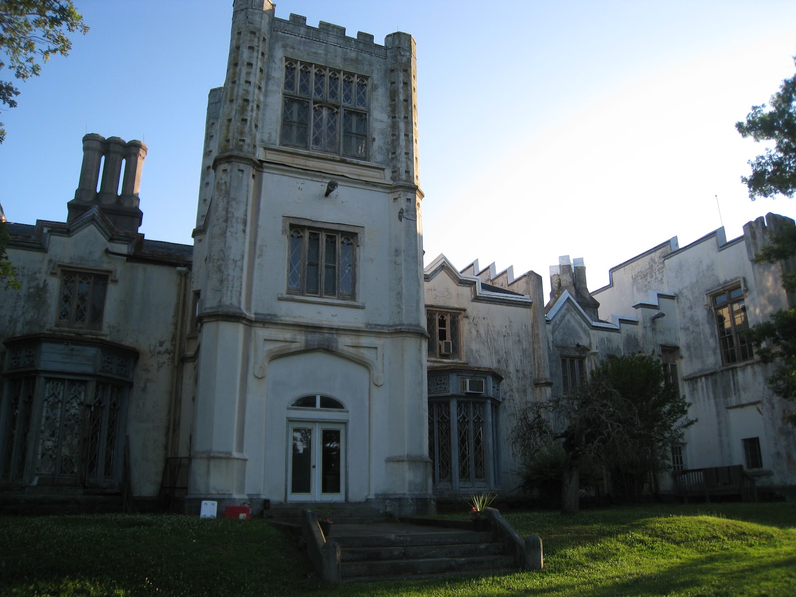
We paddled together to Belmead, a mysterious old place on the river that is maintained and used by the Sisters of the Blessed Sacrament.  As a neighbor, Betty knows the Sisters there well, and among other things has helped develop nutrient management plans for crops that are grown on the 2200-acre property.  Approximately half of the land has been put into a conservation easement for permanent protection.  The Sisters are very committed to environmental stewardship while also trying to preserve historical treasures on the property.  Two grandiose buildings look over the property, which formerly served as schools for African American and Native American students starting in the 1890s.  I've never seen any place like it...nor met anyone like the Sisters!

The mansion at Belmeade convent, formerly St. Emma school (boys school)
 
Sister Elena (left) and Sister Jean (right) were very excited to find this big turtle. The turtle was less excited.

Front of former St. Francis school (girls school) on Belmead property.


Buckingham to Cumberland County

On the road again! Ryan dropped me off at the New Canton boat landing in Buckingham County on Tuesday, where we ended our paddle trip on the James River last week.  For the rest of the day I walked through the northeast tip on the county and shortly into Cumberland County.  I passed lots of logging trucks along the way...or they passed me, I suppose.  I had associated Buckingham with tree plantations and slate, and I wasn't dissapointed!  In fact, after getting a chance to talk a while with Mr. Bryant of Bryant and Sons general store, he made sure I knew about Buckingham slate and pointed out his "established in 1965" sign out front.  Once I crossed into Cumberland, I wasn't sure how they would feel about slate from next door...but, it turns out they do like slate in Cumberland too.

In the afternoon I had a chance to visit with Bill and Stephanie Osl who run a cattle farm in Cumberland.  They were very nice to have me for dinner and spend the night on short notice.  Bill also sits on the Board of Supervisors for the county, so he was able to fill in my non-existent knowledge of Cumberland.  Agriculture (mostly poultry barns) and logging are the primary businesses in the county and history of the jurisdiction goes way way back.  I learned about a new reservoir that the county and other surrounding localities plan to build in future years to provide water from the James River to its citizens, as well as an exciting new prospect of a poultry litter "digester" that would capture the methane from decomposing poultry waste and convert it to energy.  It would be the first of its kind built on a communty scale.  Right here in Cumberland County.

Glad to be out again,

Laurel
P.S.  My achilles felt decent after a day's walk, though a little creaky.  As my brother said, I'm just not 20 anymore.


Mr. Bryant of Bryant and Sons store points out his slate sign.

I crossed through the northern tip of both counties, near the James.


Tank farm, northern Cumberland County.


Dairy in the distance.

Stephanie and Bill Osl.  Bill sits on the Cumberland County Board of Supervisors.

Stephanie Osl feeds bulls right out of her hand. Woah.

Stephanie and Lucy on their daily walk.


A short break...to be continued


Testing out the new shoes - this time with some weight!
I ended up coming home on Wednesday when Ryan headed back home, so I could test how my achilles tendons might hold up for walking the eastern half of my planned route.  A visit to a podiatrist confirmed that the shoes I hiked in simply were too small and bruised my achilles, but a bigger pair of shoes and some heel cushions should allow me to keep on trucking.  Luckily the shop where I got fitted for those shoes originally took back the first pair and gave me a larger size for free (I think showing them a gruesome photo of my heels helped)!  I will start up again early next week where we left off at New Canton and try to take it a little easy on the miles at first.

This short break has allowed me to catch up on blog entries that I missed earlier.  Scroll down to see new posts and/or photos for May 18, 19, 20, 22, and 24!

Looking forward to showing you more images and stories soon from our great state,

Laurel

Day 13 - 15: Lynchburg to New Canton

 After all those dam portages upstream of Lynchburg, Ryan and I kept paddling down the James for another three days before he needed to head home.  We made it to the boat landing at New Canton in the middle of the state, for a grand total of 150 miles on the James River in seven days.  And my achilles tendons were VERY thankful - best decision we could have made.  We had walked about 80 miles before getting into the canoe, but  "Walk Across Virginia" is a bit of a misnomer at this point, isn't it? I don't regret getting to know the James River up close, though. 

Fountain on the James in Lynchburg
There were some things I did not expect about the James River.  I was surprised by how little infrastructure and few buildings there are in view from the river - the one exception being railroad tracks.  I also didn't expect to see so many people fishing and so few people on the river canoeing or kayaking like us.  The high waters from heavy rains could have had something to do with that too.  Speaking of high water, because of the murkiness from dirt and silt, it was rare to be able to see the bottom of the channel even as we skirted along the banks on those last couple days.  I was surprised how long it took for clarity to improve.  But despite the brown water, the critters hadn't gone anywhere.  Everyday we saw big turtles sunning themselves on nearly every log that poked out of the water.  We saw all different kinds of ducks; several osprey and a bald eagle; muskrats and an otter; and many Canada geese...oh, and certainly some cows in the Piedmont section below Lynchburg.


Pulling out of Lynchburg a little later than we hoped - but that pizza was worth it!

One of Lynchburg's combined stormwater and sewer outlets into the river - a.k.a. when it rains hard, stormwater runoff mixes with raw sewage and dumps into the James.  At the Center for Watershed Protection, we are trying to help in the City's efforts to reduce runoff so that this doesn't happen as often.

Cows bathing in the river - a more common occurrence in the Piedmont section below Lynchburg.

Checking the map to see how much further to Bent Creek.


A harmonica interlude between paddling.

One of the prettiest riverbank spots we found to camp.

Morning fog near camp spot.

Mornings were the most special time to paddle.

The canoeing couple.

One of Pat Calvert's (Upper James Riverkeeper) signs, spotted at Wingina boat launch.

They only sell stamps and envelopes here. The old store is now used as the post office and a museum.

Riverbank trees hold on for dear life.

Ryan doesn't like getting sunburned.  Can you tell?

Home of Karen Firehock and Tim Lewis - historically the Howardsville Bank. They spent the last year renovating the house into what is now an incredible place. They treated us like royalty after we boated in for a visit...showers, dinner, a bed, and even breakfast = Howardsville Heaven.

Weasel Junction Hunt Club near the boat landing in Howardsville.

Four friends joined us to paddle from Scottsville for one last fun day on the water.


Time for the canoe and Ryan to head home - and I have come home for a few days to get my achilles checked out.

We did alright with a canoe and a couple paddles, didn't we Hon?

Looking back at the Upper James

The last five days canoeing on the James have been eye-opening for me. Ryan kayaked the entire length of the river back in 2007, but for me the upper reaches of the river that we have been paddling are all new. Although the scenery is mostly consistent (steep wooded banks, gray green water, train tracks) there still have been distinct features in  each stretch that we have paddled.

That first day when we were on the river with Pat Calvert in the upper James above Buchanan, the river was hugged by the hillsides and limestone cliffs. The National Forest flanks the river most of the way down, sometimes on both sides, so it was rare to see a house or field. There is good reason that some of this part of the James has been designated a National Scenic River. Interestingly, "No Trespassing" signs were much more common in this area west of the Blue Ridge, presumably because of adjacent public lands. Most of the people we ever saw up there were out fishing - we were the oddballs in a canoe without a line. The water was high from a couple days of heavy rains, so we were able to cover 21 miles in about five hours without much effort.

Laurel

Day 11 - 12: Dam Portages Above Lynchburg

I've got some new beef with dams. After all the fun of running through the rapids at Balcony Falls near Glasgow, things got less fun.  There is a reason very few people navigate down the James River between Glasgow and Lynchburg - seven reasons, in fact.  I, Ryan, the canoe, our paddles, and multiple bags of gear had to portage five of the dams on foot and two with the help of nice people with cars (I think we mentioned Fred's help earlier - thanks!).

First portage without the help of a vehicle - Bedford Power Dam
Now, tell me if I'm out of line here, but when humans put a big barrier across a river, shouldn't they also provide a simple and safe way for other humans with boats (and no vehicle) to get out and back into the river so they can keep going on their merry way? If VDOT put up a long jersey barrier across I-64 without providing a detour...you know how long that would last. I'm not even talking about a nice concrete ramp and a formal walkway - I would be happy with just a few stable steps up the bank or a dirt path that is kept cleared without having to trespass through someone's property or along the railroad.  And in cases where the only put-in after the dam is, say, 1.5 miles downstream, it sure would be nice to get a little lift from those responsible for putting up that infrastructure (ahem, Georgia Pacific paper plant).

As it is, for most of the portages Ryan and I had to scout out the riverbank for a spot flat enough to hoist up the canoe out of the water and then walk around to make sure there was a place to pull the canoe and gear around the dam and back into the river on the downstream side.  Portages came in all varieties:  pulling the canoe across and lowering down boulders (sorry, Fred, we owe you some patch work on that canoe); trampling through mud flats and tall grass; scrambling through woods and poison ivy; and in the case of the paper plant portage at Big Island...waiting until some nice people at the boat landing with a vehicle feel sorry enough for us to give us a lift.

Father and son who had been fishing at boat ramp above Georgia Pacific paper plant. After I walked back from unsuccessfully looking for someone at the plant who might give us a ride around their facility, the fishermen offered us a ride in their van.  They saved us a mile and a half of lugging a canoe and gear!

The fawn that Ryan almost stepped on as he lugged the canoe through a soggy area with tall grass (Coleman Falls dam).

The aftermath of sinking into a mud pit and losing my right sandal (Coleman Falls dam).  I thought it was a goner, but a couple minutes of probing in the mud brought it back from the depths.

Ryan pulling the canoe past the Colman Falls hydroelectric dam.  Thank goodness for the muscle man.

Hello, Holcomb Rock dam.

Yes, you are aptly named, Holcomb Rock dam.

Goodbye, Holcomb Rock dam.


Dam, that was some hard work.

Yours truly,

Laurel

A good rest under the Blue Ridge Parkway


Laurel taking a well deserved nap after a full day of whitewater boating and two successful dam portages.   We have five more to go.   We might give the Big Island portage a try this evening.  There is a factory there and if the plant worker's wont help us then it is a two mile road walk.   Hitchhiking with a canoe???


Day 11: Not all rivers are smooth


Today we were joined by Ryan's father Fred and George Bowles for a great run down the Balcony Falls section of the James.  Thankfully our canoe stayed upright although we did get a good bit of water in it a few times.   Fred also gave us a very needed ride around the Cushaw Dam.   The portage around the dam was fine but the rapids right below looked a bit too difficult for our canoe laden with camping equipment.